 France
  Spain
Spain  German
  Italian
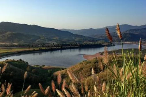
Mae Ping River Cruise
The Mae Ping River flows through the city of Chiangmai and provides the surrounding rural countryside with its much needed water for irrigation of rice paddies, gardens and crops. The Mae Ping is known to locals as the “Lifeline of the Province”. The river is 569 Km long, and has its source in the mountains near Chiang Dao, in the northernmost part of Chiangmai Province. It flows southward, creating the beautiful and agriculturally rich Maesa Valley that leads to the northern edges of Chiangmai. As it flows through Chiangmai, you can readily see how the city was carefully built up along the river, in the Thai tradition, and how it has developed over the past 700 years. Mae Ping River Cruises offers hourly boat rides on the Mae Ping River. It’s easy for visitors to call (Tel. 274822) for transport to the pier at Wat Chaimongkol pier for a leisurely ride up the river to their own private garden where visitors can touch and taste many Thai herbs then enjoy a cool dish of fruit and a beverage. Also, an evening boat ride with dinner is very popular entertainment for visitors and Chiangmai residents as well. Your group can provide their own on board singing entertainment with the cordless microphone provided by the cruise company. From Chiangmai, the Mae Ping flows further southward and gradually widens as it passes through the ancient northern town of Lamphun (pronounced “Lumpoon”), a Mon center established in the ninth century. Beyond Lamphun, it flows southwestward to the town of Hord, from where it takes a more direct southerly route to Tak and Khamphaengphet, and ultimately to Nakon Sawan where it empties into Thailand’s largest river, the Chao Phraya. All along its route, some of the country’s most beautiful scenery accompanies the river. From its source at Chiang Dao, vast hardwood forests cover much of the surrounding land. In the Mae Sa Valley, the forests gradually give way to rich, fertile rice paddies, and beautiful natural flower gardens in the wild. Lumyai orchards, and plantations of coffee, tea, strawberries and tobacco flank the banks of the river as it gets closer to Chiangmai. After widening some at Chiangmai, it makes an even wider path through the fresh fruit orchards of the Chiangmai Plain, until it dips along with the terrain to make its way to the Central Valley rice growing area. For all its length and the many benefits it affords the land and the people along its meandering path, the Mae Ping is still most often associated with Chiangmai City. This is probably because of Chiangmai’s historic role as the capital of Lanna Thai and its present-day reputation as the capital of the North. This river is, in fact, one of five that make northern Thailand such a rich center of wet rice farming. The others are the Mae Kok, which runs from west to east through Chiangrai Province and empties into the Mekong River at Chiang Khong; and the Mae Wang, Mae Yom and Mae Naan Rivers. These three follow north to south paths and merge with the Mae Ping at Nakon Sawan before all four empty into the Chao Phraya. The significance of Northern Thailand’s river featured topography is that the land, the people, their towns and their homes, and most importantly their way of life, have always been focused on these waterways. More than most peoples in other parts of the world, the Southeast Asians, and particularly the Thais, are dependent on rivers in a very large number of ways. For example, the annual overflow during the rainy season supplies not only new silt deposits for fertile agriculture, but also a plethora of fish which suddenly appear on the land, and provide an important source of food and protein. From the houses on stilts to the family boats and fishing nets, many features of traditional Thai lifestyle focus on the river. For over 700 years, the Mae Ping River has been a major source of water for Chiangmai. Historically, the Mae Ping provided the people in and around Chiangmai with water for washing, bathing, and irrigating their gardens and rice paddies; the river was also a source of food and was used for the transport of people and goods. At the turn of the century, it was estimated that more than a thousand boats moved along its course between Chiangmai and Tak. Boats still ply its waters, although the number of boats has diminished greatly over the last century, and the river itself is shallower and less swift than formerly. Though physically less of a river than it was a hundred years ago, it still plays a vital role in the lives of thousands of Thais who live on its banks. In more recent times another feature of great rivers of the North is the dams that have been constructed at various points in the geography. These help in situations where the river, like the Mae Ping, is about to flow into a big city where flooding is no longer desirable because farmland has been eliminated. In Chiangmai the effect of the dam can be seen with the relatively stable river level, even in Thailand’s hot season. Boats still move people and goods along the Mae Ping; fishing nets are still cast into its waters by people in search of food; each day people bathe and wash clothes in its waters. One can follow the Mae Ping’s course quite easily as it flows south out of Chiangmai. And even before the river is out of the city limits, the life along its banks is traditional rural Thai. Along its banks most of the homes are Thai-style wooden houses, the dress of most of the people is traditional, and the single most important activity is agriculture. It is possible to explore the Mae Ping either by land or by boat. Traveling along the small, often unpaved roads that wind alongside the Mae Ping, one will encounter village after village where people’s lives follow the dictates of the seasons and age-old traditions, people whose smiles are frequent and sincere. Other than villagers on bicycles, motorcycles or ox carts, one experiences very little traffic on these roads. One is never far from a village, and finding a place to get a bite to eat or a cold drink is never difficult. Don’t be surprised if the prices of food and drink at a small store or restaurant is half of what you might expect in Chiangmai. Plan on making these adventurous day-trips, for you are not likely to find a hotel or guest house along the banks of the Mae Ping outside of Chiangmai proper.
Chiang Khong
Chiang Khong is a fast-growing town in Chiang Rai Province, Northern Thailand. It is mainly visited...
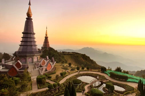
Doi Inthanon
The highest peak in Thailand, Doi Inthanon rises to a height of 2565 meters (8, 415 feet) above sea...

Doi Suthep-Pui National Park
Often bearing a crown of clouds, Doi Suthep (1676m) and Doi Pui (1685m) are Chiang Mai’s sacred peaks....
Lanna Folklife Museum
The Lanna Folklife Museum is an interesting museum full of exhibitions about the lives, history and...
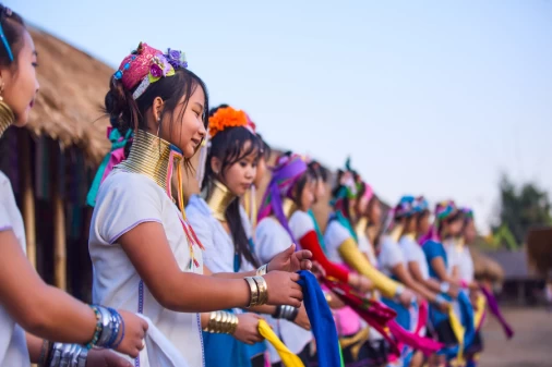
Long Neck Hill Tribe & Chiang Dao Cave
Boasting some of the most spectacular stalactite and stalagmite formations in the country, Chiang Dao...
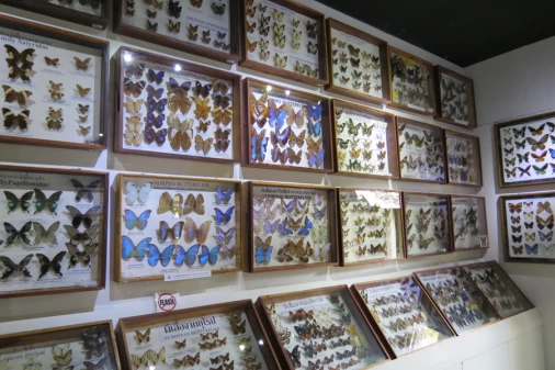
Museum of World Insects and Natural Wonders
The nature history museum displays a worldwide collection of many thousands of amazing specimens of...
 Vietnam Tours
  Cambodia Tours
  Myanmar tours
  Thailand Tours
  Laos Tours